East Sea tropical depression likely to become next storm
- Cooperation needed to manage potential conflict in East Sea: seminar
- ASEAN, China agree to protect marine environment in East Sea
- Cooperation, dialogues important to East Sea dispute settlement: scholars
- China asked not to complicate East Sea situation
The Centre reported that at 1pm on November 17, the eye of the tropical depression was located at 9.5 N, 119.5 E in the eastern area of Palawan Island in the Philippines. The strongest winds near the centre of the tropical depression are estimated to be at category 7, with maximum speeds of 40-60km per hour.
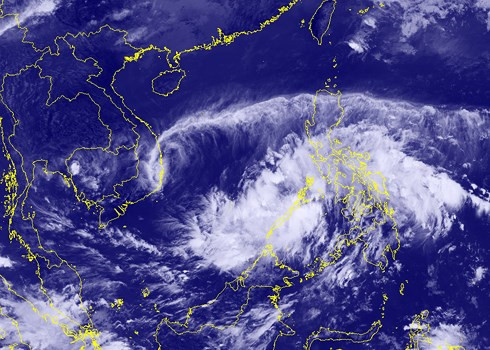 |
| The National Centre for Hydro-Meteorological Forecasting announced on November 17 that a tropical depression is moving towards the East Sea and is likely to strengthen into a tropical storm. |
In the next 24 hours, the tropical depression will move west–northwest at a speed of 25-30km per hour, and will likely strengthen into a storm.
Due to the circulation of the tropical depression, heavy downpours and thunderstorms will occur over southern waters in the East Sea.
In the next 24-48 hours, the storm will continue its rapid move west-northwest at a speed of 25km per hour.
The Central Steering Committee for Natural Disaster Prevention and Control sent a telegram to the coastal localities from Da Nang to Ca Mau and Kien Giang, and to relevant ministries and agencies to take proper measures in response to the storm.