Police asked to proactively respond to natural disasters
- Minister urges synchronous measures to deal with natural disasters
- Ha Giang Police active in supporting local victims of natural disasters
- PSF proactively prepare for possible natural disasters in 2018
The dispatch, signed on July 17, was sent to the steering committees for climate change response, disaster prevention and recue of the under-ministerial agencies and units as well as police force of provinces and cities, possibly affected by the incoming storm, rom Thanh Hoa to Thua Thien Hue.
 |
| Police officers helping people in floods. Photo for illustration. |
To actively respond to possible floods and rains, the Steering Committee for Climate Change Response, Disaster Prevention and Rescue under the Ministry of Public Security asks all above mentioned units to:
Strictly implement dispatch 11 / CD-TW issued on July 16, 2018 by the Permanent Office of the Central Steering Committee for Disaster Prevention, and the Office of the National Committee for Search and Rescue; and directions of local authorities in response to dangerous weather.
Closely monitor developments of rains and floods from the mass media and actively coordinate with relevant units to ensure safety for people and assets, especially for fishing vessels.
Coordinate with local authorities and functional forces to provide necessities to badly-affected people and conduct search for missing.
Direct the traffic force to support people in travelling through water-logged roads and dangerous areas.
Implement plans to protect documents, means and working facilities of the public security forces safely.
Relevant units to be on 24/24h duty and to periodically report the Permanent office of the Steering Committee for Climate Change Respond, Natural Disaster Prevention and Control, Search and Rescue on the local situation and developments of the storm and other related natural disasters in the locality.
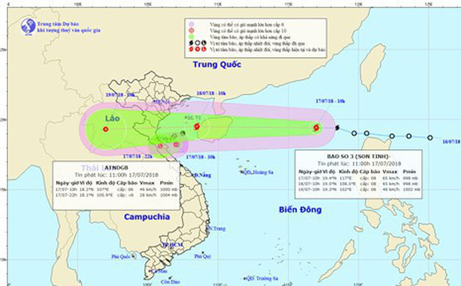
According to the Central Hydro-meteorological Forecast Center, tropical storm Son Tinh, the third entering the East Sea in 2018, is forecast to make landfall in coastal localities from Thai Binh to Ha Tinh on late July 18.
 |
| The third entering the East Sea in 2018, is forecast to make landfall in coastal localities from Thai Binh to Ha Tinh |
At 4:00 am of July 18, its eye was about 470km west of the Hoang Sa (Paracel) islands with maximum sustained winds near the storm’s eye of 75-90km per hour. In the next 24 hours, Storm Son Tinh is quickly moving westerly at a speed of 25-30km per hour.
Due to the storm, there will strong rainstorms and rough seas across north-western East Sea (South China Sea), and high tides in coastal areas of the northern and north central sub-regions of the country.
It may also cause heavy rains until July 20 in the northern delta and midland.
Mountainous areas in the northern and north central sub-regions may face flash floods and landslides, while lowland and urban areas in the provinces of Hai Duong, Nam Dinh, Ninh Binh, Thai Binh, Hoa Binh and Hanoi, as well as localities from Thanh Hoa to Quang Tri may be submerged by floodwater.