Tropical low pressure enters East Sea, likely to become typhoon
Forecasters said the strongest winds near the centre of the system were estimated at 40-50km per hour.
Over the next 24 hours, the system is expected to move west at a speed of 30km per hour and is likely to strengthen.
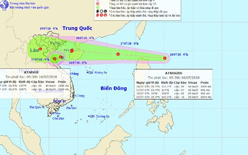 |
The centre predicted that the tropical low pressure will hit the East Sea from tonight (July 16) until 7am on July 17, the centre of the system will be positioned in the north of East Sea, about 650km to the east ofHainan Island with strongest winds reaching 50-60km per hour.
Due to the effects of the tropical low pressure, strong winds, downpours and thunderstorms affect the east of the northern region with rough seas.
Over the next 48 hours, the system will move rapidly to the west at a speed of 30km per hour and will intensify with typhoon. It will impact the Tonkin Gulf, north-eastern coastal provinces, the northern delta and the north central region.
In addition, due to the impact of the tropical convergence strip, and south-west monsoon, there will be strong thunderstorms, tornadoes and gales in East Sea and coastal provinces from Binh Thuan to Ca Mau, Kien Giang and the Gulf of Thailand.