Typhoon Rai entering East Sea, making U-turn
Super typhoon Rai that pounded the Philippines on December 16-17 is entering the East Sea and is expected to make a U-turn when it moves closer to Vietnam’s central coast, according to weather forecasters.
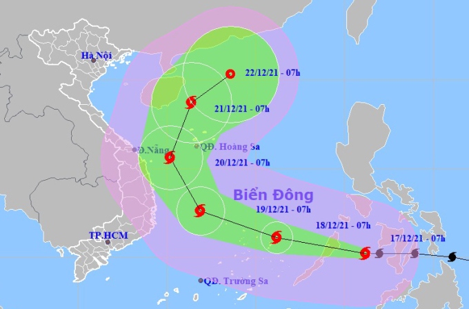
At 07am on December 17, Rai was sweeping across the central coast of the Philippines, packing winds of 185kph near its eye.
The typhoon is forecast to move west and north-west and lose its strength a bit in the coming hours before entering the East Sea in the evening.
Rai is set to sustain winds of 150kph on its path towards Vietnam’s central coast in the next 48 hours and suddenly change its direction toward north and north-west.
The typhoon is likely to go northward, which is an abnormality in its path compared to other storms that hit Vietnam in previous years, Tran Quang Nang, an official of the National Centre for Hydro-Meteorological Forecasting.
In an urgent telegram released on December 16 evening, Prime Minister Pham Minh Chinh requested localities from Quang Ninh to Ca Mau to closely monitor the development of the typhoon and draw up response plans.
Top priority will be given to protecting local people’s life, said the PM.
Rai packing winds of more than 200kph slammed into the Philippines on December 16-17, flooding parts of the central region and bringing down power transmission lines. Nearly 200,000 people have evacuated from their homes to safe shelters.